Storm Team4 Forecast: Easygoing weather in the 70s for Election Day in DMV
4 things to know about the weather:
- Nice & mild Tuesday, Wednesday
- Some Thursday showers
- Rain could be heavy Friday
- Cool, dry weekend
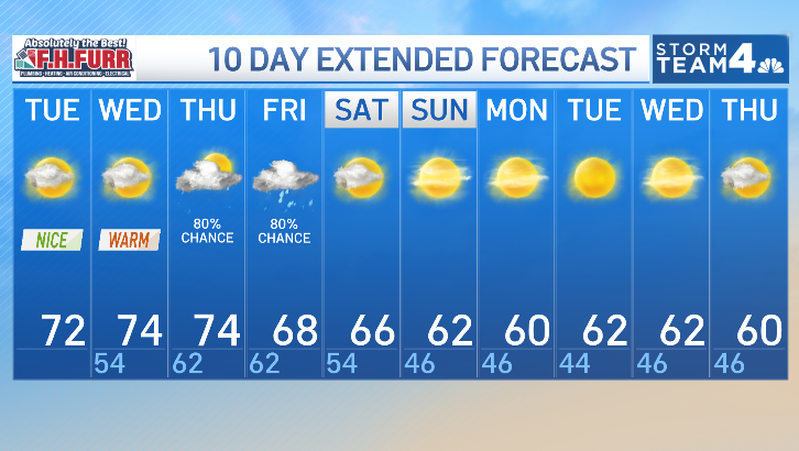
A storm organizing over the Great Plains will finally bring rain back to the mid-Atlantic by Thursday and Friday. These will be our first raindrops in two and a half weeks.
Ahead of that storm, southerly breezes will keep our temperatures well above our seasonal averages of 63°/46°. Highs Tuesday will be around 70° and Wednesday afternoon closer to 75°. Both days will come with periods of sunshine mixed in with some low to mid-level clouds.
There’s also the risk of fog in the sheltered valleys and water crossings these next few mornings as overnight lows will remain in the low to mid-50s Tuesday night and close to 60° Wednesday night.
When will it rain?
Rain is likely to impact both Thursday and Friday but in very different ways. Thursday’s rain doesn’t look like much. A periods of showers looks likely between 6 a.m. and noon but with rainfall totals generally less than a quarter of an inch. Thursday afternoon looks to be mainly dry but unusually humid and mild with highs in the low 70s for most.
Download the NBC Washington app on iOS and Android to check the weather radar on the go.
Friday’s rain looks far more long lasting and could be locally heavy. A slow moving cold front will bring at least some rain to the I-81 corridor but could deliver 1-2 inches along and east of I-95.
Several of our forecast models are showing a stripe of heavy rain running from Williamsburg and Richmond up to the northern neck, southern Maryland, the lower Bay and the southern half of the Delmarva Peninsula. Those same models are only delivering around half an inch in the D.C. metro area.
Needless to say, we’ll have to wait, watch and see where this heavy rain chance develops. Just keep in mind that our Friday could range from damp and drizzly to a solid soaking.
One that that is certain is that Thursday and Friday will both be mild and very humid. Highs will reach the low 70s on Thursday and be near 70° on Friday. The way things look now, the rain should be out of our area by daybreak Saturday leaving us with a mainly dry weekend.
It will also turn cooler and stay cooler with a significant pattern change. Highs this weekend will be in the low to mid-60s on Saturday and then struggle to reach 60° from Sunday onwards through all of next week.

QuickCast
TUESDAY:
Some fog at daybreak
Mostly cloudy morning
Some afternoon clearing
Wind: south 6-12 mph
Chance of rain: 0%
HIGHS: 68° to 73°
TUESDAY NIGHT:
Mainly clear evening
Mild for November
Patchy fog by morning
Wind: south <5mph
Chance of rain: 0%
LOWS: 50° to 55°
WEDNESDAY:
Some morning sunshine
Increasing clouds
Nice and mild
Wind: southeast 5-15 mph
Chance of rain: 0%
HIGHS: 72° to 77°
THURSDAY:
Cloudy, mild & humid
Periods of light rain likely
Rainfall less than 1/4”
Wind: southwest 5-15 mph
Chance of rain: 70%
HIGHS: 68° to 74°
FRIDAY:
Cloudy and humid
Rain likely much of the day
Locally heavy rain possible
Wind: southwest 5-10 mph
Chance of rain: 80%
HIGHS: 66° to 72°
Sunrise: 6:37 Sunset: 5:05
Average High: 63° Average Low: 46°


Stay with Storm Team4 for the latest forecast. Download the NBC Washington app on iOS and Android to get severe weather alerts on your phone.
Ver nota original ↗
¿Querés un resumen rápido de esta noticia, hecho por nuestra IA?