NWS resumes twice-daily weather balloon flights nationwide: What it means for Mid-South forecasts
MEMPHIS, Tenn. (WMC) - The National Weather Service (NWS) has officially returned all 92 upper-air sounding stations nationwide to a full, twice-daily weather balloon launch schedule, ending more than a year and a half of operational cutbacks.
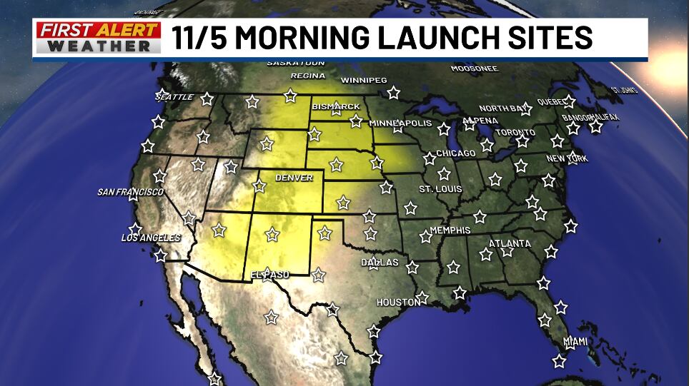
Effective Nov. 1, every sounding site across the country resumed standard launches at 00 UTC and 12 UTC (6 p.m. and 6 a.m. CST). The move provides an immediate boost to numerical weather models and forecasters heading into the heart of severe storm and winter weather seasons, restoring critical real-time atmospheric data that had been missing across vast stretches of the United States.
Before & After: Closing the Atmospheric Blind Spot
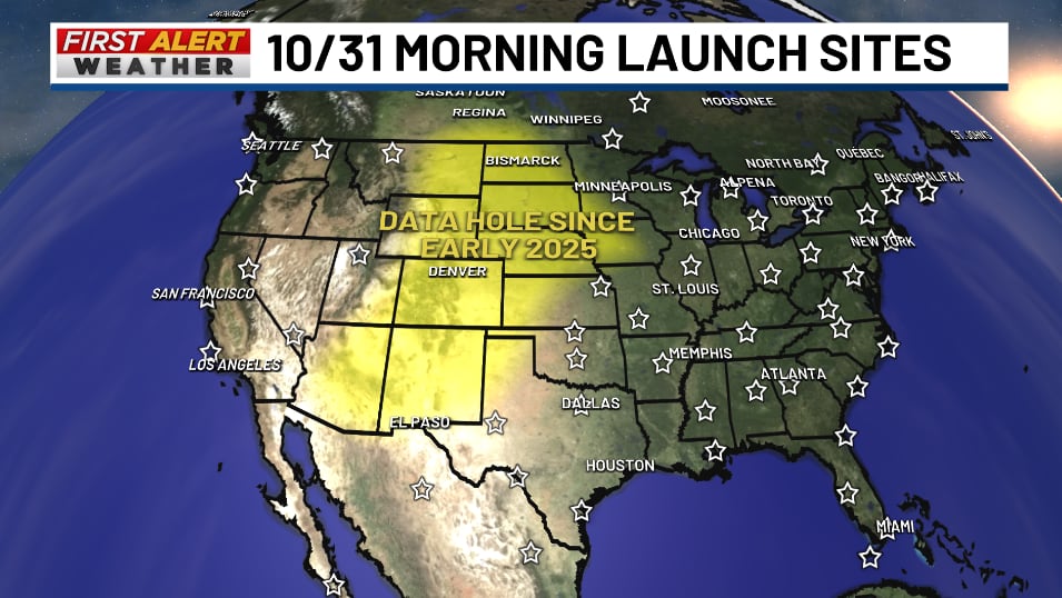
The difference in observational data coverage between late October and early November is stark. Take a look at the two launch coverage maps below:
What Happened Over the Past 18 Months?
Beginning in early 2025, budget constraints and staffing reductions forced the NWS to scale back daily upper-air operations. At dozens of stations, soundings were cut from the standard twice-daily cadence down to just one launch per day, while some offices lacked the personnel to launch at all.
As shown in the October 31 map, the brunt of these reductions fell directly on the Intermountain West and the High Plains east of the Rockies. For meteorologists, this created an atmospheric blind spot directly upstream—in the exact geographical corridor where mid-latitude cyclones, severe storm systems, and winter cold fronts take shape before tracking east toward the Mid-South.
Why Weather Balloons (Radiosondes) Are Indispensable
While satellites offer high-resolution imagery of cloud tops and Doppler radar tracks active precipitation, neither tool can physically sample the thermodynamic profile of the atmosphere from ground level to the stratosphere. Weather balloons carry an instrument package called a radiosonde, ascending past 100,000 feet while transmitting direct measurements:
Temperature and Lapse Rates: Measures how rapidly air cools with height, defining convective instability and the strength of capping inversions.
Moisture and Relative Humidity: Profiles vertical water vapor depth, which dictates cloud formation, precipitation efficiency, and winter precipitation type.
Atmospheric Pressure and Winds Aloft: Tracks the jet stream, shortwave energy, and vertical wind shear necessary to diagnose severe storm organization.
Global models such as the GFS and ECMWF ingest this observational data during 00Z and 12Z data assimilation cycles. When soundings are absent, models approximate atmospheric initial conditions. Over successive forecast cycles, those estimations compound into run-to-run volatility and reduced forecast confidence.
What the Restored Launches Mean for the Mid-South
With all 92 stations back to standardized 12-hour schedules—and the capability to execute special 06Z and 18Z soundings ahead of significant high-impact weather—forecasters in the Mid-South can expect several tangible improvements:
Enhanced Medium-Range Timing: Greater consistency in the arrival timing and frontal structure of weather systems emerging from the Plains 3 to 7 days out.
Sharper Severe Weather Assessments: More accurate model handling of elevated mixed layers (plains dry air plumes), cap strength, and low-level jet development.
Reduced Model ‘Flip-Flopping’: Fewer erratic model shifts between consecutive model runs when resolving progressive trough energy across the central United States.
Click here to sign up for our newsletter!
Click here to report a spelling or grammar error. Please include the headline.
Ver nota original ↗
¿Querés un resumen rápido de esta noticia, hecho por nuestra IA?